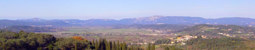
Get Away From the Crowds in Central-West CorfuPlease note that this guide was written some years ago. It could be that the route may now be inaccessible in places. It is a good idea to check locally wherever possible. August is the month of busy roads, packed beaches, jammed parking areas and, in the resorts, crowded streets and hassled waiters. But you can avoid August Fever by staying away from the most popular haunts, the ones Athenian visitors go to see and be seen, and Italian tourists say 'ciao' other Italians and admire each other's cars. If you're heading west, steer clear of Glyfada and Paleokastritsa, the worst of the August hotspots, and turn instead to the countryside, the villages and the lesser known beaches. Even in August, you can find peace. This summer, we recommend an exploration of the central-west area of the island, avoiding of course the 'tourist traps'. We begin our tour from Corfu Town, but if you are not staying there, consult a map to get onto the main road which leads west towards Pelekas (the best map currently in print is the 'Road Map'). The first major junction comes six kilometres from Town, where a road heads off left to Pelekas, while the main way continues past Aqualand and into the Ropa Valley. (With traffic at its annual peak, and the presence on the road of the notorious Athenian and Italian drivers, it is worth considering that this highway is the least scary and least busy of the routes out of Corfu Town.) Close to this junction, a couple of hundred metres along the road to Pelekas, is the turn-off for the Triklino Vineyard, so if you're passing here after midday, or returning before seven in the evening, don't miss a visit. But straight on, the traffic diminishes. The next landmark (after Aqualand) is the roundabout at Kefalovrisso, near Kokkini. (How to use a Corfu roundabout - give way to the traffic coming from your right, and always assume that the other guy won't stop.) Your way is ahead, and the vast Ropa Valley soon opens up. Incidentally, the road through the valley is a very good alternative route to Paleokastritsa if you want to follow the crowds. But we are going to turn off a mile or so along, taking the road signposted Giannades, Marmaro and Kanakades. This cuts across the valley, running along a slight causeway bordered with poplar trees. Halfway across, a bridge carries you over the canalized Ropa River. If it is early and the sun's heat is still bearable, take the opportunity for a peaceful country stroll along the banks of the river, where you will only meet other walkers and the odd flock of sheep picking at the dry grasses. Park the car at the side of the road (don't worry about being completely off the road; it is little used and you won't interfere with traffic flow). Take the track along the west bank of the river (the course of the Corfu Trail, marked with yellow signs and paint markers), whose banks are lined with willows and other trees. A couple of hundred metres along the track, the Corfu Trail leaves the riverbank over a concrete slab bridge across the ditch. This point appears to be the centre of some manipulation of the landscape on a grand scale. Standing here, the track southwards - the one you just came along - aligns with the summit of Agii Deka mountain. Turn exactly 180 degrees (I have confirmed this with a compass), and a V frames the little chapel of Saint Simeon, perched on a pillar of stone on the distant 'red rock' cliffs that back Paleokastritsa. Also at this point (move just a few paces and it doesn't work due to parallax!), the Λ peak of Mount Pantokrator is exactly reflected by a V-shaped break in the ridge of hills to the east. Turn to look west and, just to the left of Giannades village. Here, the roof and campanile of a a white-washed church form twin domes. These structures lie just below the skyline of black trees, whose shape exactly matches their curves. Move a couple of steps north or south, and, just as the Λ of Pantokrator and the V of the gap in the hills no longer align, so the white silhouette of the church against the black of the trees no longer correspond. These two points do not align in a 180 degree swing, but rather are visual geographical phenomena. I have maybe identified a third alignment, this one also on a 180 degree line running through the point where you are standing. This comprises the summit of Vatos mountain, topped by the chapel dedicated to Saint George, and the Spanopoulos mansion on the line of inland hills, where there is also a chapel of Saint George. In each case, the alignment at one end is defined by a distinct geographical feature (a mountaintop with an old church or monastery on it) and at the other end another chapel which is not located on a fixed geographical feature, but which could have been placed in its position deliberately. It is also worth noting that a ford crosses the river at the point where you are standing - always the sign of a significant setting, and a regular component of ley-lines. Could this little point in the Ropa Valley be the hub of a ley-line system? If you can drag yourselves away, continue along the riverbank for about a kilometre, where a stone bridge links the track you are on with the other bank, and you can stroll back to your starting point along the parallel track, which offers slightly different views to the east instead of in a westerly direction. Back in the car, continue along the road until you reach a crossroads, where a road bears off right to Marmaro. If you are in an ordinary car, go right here and wend you way through the villages of Marmaro and Kanakades to rejoin the main Ropa Valley road. Here you turn left and continue along the valley until the turning for Liapades. Take this road, go right at a T-junction, and head down to the sea, where the road stops. If you have a 4x4 and a sense of adventure, keep going to Giannades. Immediately before the square (stop for a coffee if you like - but we will be back later) take a lane to the left, which carries you to the top of the village and down into a shallow valley at the rear. The road, shortly turning into gravel, swings to the right around the valley and runs along the side of the ridge, with glorious views back to Giannades and over the Ropa Valley. Ignore tracks going uphill to the left, and deviations to the right. The main track is clear - and it is the course of the Corfu Trail, marked throughout with splashes of yellow paint. After a sharp climb up a valley, turn left at a T- junction and climb to the top of the ridge. Over the top, you plunge into olive trees. At the first junction, bear left, then at the second right (following still the Corfu Trail). Then you chug along on the rough road, with sudden vignettes of the sea below from time to time, until you reach asphalt at a junction with a little shrine. Straight on here, and follow the asphalt down into Liapades (the Corfu Trail leaves the road just before the village - don't be tempted to follow it at this point, as it enters the village by way of a path!). The road into the village is steep and very narrow - rather scary in fact - but persevere and you join the main Liapades village road. Go left to the square for well-deserved refreshment (parking in the square is strictly speaking not allowed, but providing you are prepared to move your vehicle in a hurry, you can stop there for a short while). Or go right to exit the village. At the foot of the settlement take a road straight on and head downhill to the beach, where you rejoin the tour taken by the less adventurous. Liapades Beach does not rival the extensive strands of the central west coast, such as Glyfada and Agios Gordis, neither is its sand so fine and golden as theirs. But it does have a much finer outlook. Since it is located in a deep-cut bay, its view out to sea is fringed with forested hillsides, which focus the gaze along the Paleokastritsa coastline. Few buildings are in sight, so that you can hardly tell which century you are in. The big fun of Liapades is hiring an outboard motor boat. The coast to the south, as far as Ermones, is sheer and precipitous, with few beaches accessible even on foot. Which makes a sea-bourne exploration a must. It is advisable to keep close in to shore, and head for land if a strong wind gets up. The first beach you pass is Rovinia, made famous by Emma Tennant's book 'A House in Corfu'. But this beach has got itself a road now, and is much busier than in the past. So head on to Limni, a spectacular double-sided beach which links a small promontory with the coast. The strand is pebble, but the sea is crystal-clear. Further along the coastline, beaches of beautiful golden sand, interspersed by sheer hillsides blanketed in a patchwork of green and by twisted rock formations and sea-caves, are tucked under high cliffs. Take some snacks and plenty to drink, and bask in a reasonable degree of solitude... If you like, end your day by heading back to Giannades, this time along the valley road. The village has been greatly upgraded in recent years, with paved lanes and alleys and a remodelled square with bird's eye view over the Ropa Valley. Park in the designated area below the square and take a stroll around the village before sitting down to your supper. Walk through the main square and along the lane to where it opens out a little. Take an alley left, down to a delightful spot, accessing an old mansion and its lovely courtyard. Two ancient and beautiful stone archways adorn the wall on the right. Return to the main lane. You can either go back to the square or, if you want to work up an appetite, make a circuit of the settlement. To do this, you turn left at the main lane and keep going. The lane runs along a shelf, open on the left. Ignore smaller lanes leading up to the right. At the rear of the village, pass a road coming in from the left, then go straight on. After climbing slightly, you re-enter the village on the other side, and the narrow road drops to the square again. You can now enjoy your meal. In the corner of the square, next to the original coffee bar, a new grill room - 'Oi Kaloi Gnomoi' - has a wooden deck outdoor seating area with the best view of the valley, and you can watch as the sunlight gradually diminishes and the lights come on over the plain and on the hills beyond. The eatery serves nice nibbles to start, and excellent grills accompanied by real chips. The lamb is from their own herds, which graze on the rich valley below. A plate of tender 'paidakia' (lamb chops) makes a perfect end to a day spent away from the crowds. |
 |
|---|